Friday, January 7, 2011

Green Canyon Peregrines

Did peregrines ply the skies of riparian canyons between green canopied flanks of major Midwestern river valleys before European settlement? How common were green canyon peregrines?

Peregrine Falcons are familiarly characterized as big sky raptors of towering landscapes where stony heights offer vast vistas of prey filled sky and isolated rock ledges where falcons nest on protected eyrie's. They are modern heat-island denizens, too. They kite and flap and "kak-kak-kak" through windy gray urban canyons between monolithic buildings of urban heat-islands. Modern urban peregrines are descendant from a mix of hacked (hand-raised and released) exotic subspecies from North America, Europe and beyond. A huge effort through three decades brought these breeding peregrines to our Eastern cities. The reintroduction effort was necessary and successful, they are here to stay. Will they expand beyond urban canyons to reoccupy native haunts some day? Will they once again occupy green canyons?

Our native Eastern United States breeding peregrine form is extinct. The robust eastern form of Falco peregrinus anatum disappeared, a victim of excessive DDT used for mosquito control and "better living through chemistry" during the post-war boom years. We are still paying unforeseen cleanup and recovery costs for that era's bravado and careless economic growth, today.

Let's go back in time, back before the big wars, all of them: Imagine North America's Midwestern landscape before European settlement, visualize. A view from Space reveals Illinois' western prairie fringe blending with forest cover increasing eastward. Forest tentacles follow river valleys westward into vast prairie. From stationary satellite view, our fat green planet spinning westward under our cosmic perch reveals closing forest canopy as gathering trees coalesce. The earth turns and the landscape quickly transitions to nearly unbroken green forest canopy in eastern Indiana. Our original vast Eastern Deciduous Forest is passing under our cosmic gaze and already, irregularities are apparent. Zoom in just a little..., our view changes a lot. Green summertime canopy is imperfect at closer inspection, now we see hairlike ribbons coursing through green valleys, zoom in a little more, islands of irregular canopy appear where prairie openings pattern the sea of green. Prairie openings pockmark the glacial plains and beyond, even the eastern hills are broken by pigeon balds and rocky gorges. Ohio, for example, was ranked 95% forest before settlement, yet, prairie openings, in western Ohio, mainly, were many, some quite large. As far east as central Ohio, in Pickaway County, a six-thousand acre prairie known as the Pickaway Plains occupied the broad glacial terrace along the green canyon of the Scioto River, the green canyon and plains easily seen from high in space, even today.

Major and minor river valleys dissecting Midwestern landscapes formed permanent corridors through Eastern Deciduous Forest landscapes. These green canyons offered corridors of open sky filled with waterfowl and frequent canyon dashes by crossing passerine (perching) birds like flocks of noisy showy Carolina Parakeets, now extinct. Did peregrines hunt ribbons of open sky along river valleys?

We have few records for Duck Hawks (peregrines) nesting away from stony eyries, in the east. My home state, Ohio, has no accepted record of native nesting peregrine falcons at all. Of course, early settlement records of bird observations are few and far between anywhere you look.

I speculate that peregrines regularly occurred in green canyons of riparian corridors throughout the Midwest. Indiana records may suggest a pattern of occurrence repeated along major river valleys.

Green canyon falcons along the Wabash River...

Birds of Indiana, by Amos W. Butler, Indiana Department of Geology and Natural Resources, Twenty-second Annual Report, 1897, page 795 (italics, mine):

"Nest, in cavity in trees, and on cliffs, eggs, 3-5; pale creamy white, sometimes overlaid with light chocolate, irregularly blotched, streaked and spotted with brown or reddish-brown; 2.10 by 1.68.
Resident, not rare, in Lower Wabash Valley. Throughout the remainder of the State, rare. Migrant. Breeds. In the spring of 1878, Mr. Robert Ridgway discovered that this was by no means a rare bird in the heavy timber in the bottoms of the Wabash River, in the vicinity of Mt. Carmel, Illinois. Three nests were found there. All were placed in cavities in the top of very large sycamore trees, and were inaccessible. One of these trees was  felled, and measurements with a tapeline showed the nest had been eighty nine feet from the ground. It was placed in a shallow cavity, caused by breaking off of the main limb, the upper part of which projected
sufficiently to protect it. Four fully feathered young were taken from the nest (B. N. 0. C, 1878, pp. 163, 164).
Mr. Ridgway also informs me it breeds in Knox and Gibson counties, Ind. The Duck Hawk usually nests on the projections of cliffs, and the foregoing sites are unusual."

Thursday, April 29, 2010

Shawnee State Forest, Ohio's "Little Smokies"

We visit Ohio's "Little Smokies," Shawnee State Forest, Scioto County, Ohio April 23--25 in search of temperate and early neotropical migrating bird species.

Ohio's Little Smokies

The birds were few and far between at Shawnee this weekend due to this spring's prevailing high pressure over the Midwest limiting rainfall (no rain pools to attract shorebirds) and presenting unfavorable flight conditions for small birds eager to move northward (migrants 'stack-up' in the southern U.S.and points south waiting for low-pressure frontal systems to swing through bringing strong south winds--the wind beneath their little wings). Fortunately, a frontal system brought us some migrants Saturday morning, though still very low numbers.

A roadside apparition, moccasin flower Cypripedium acaule Aiton

Wildflowers did not let us down. Shawnee is a large tract of steep hilly woodlands criss-crossed by disturbance; roadsides & fire-breaks, intense ice-storm damage over large tracts (2003), tree pathogens--many following the ice-damage, and fire, both controlled burns and last year's 3000 acre wildfire. Plant diversity is very high in Shawnee State Forest for many reasons; disturbance is just one. Looking down for wildflowers is as tempting as looking up for wood warblers!

Yellow mandarin, AKA nodding mandarin
Prosartes
maculata (Buckley) A. Gray

My friends, Julie & Ken Davis, with my wife Jackie and I searched high and low for birds and we did find 107 species between Columbus and the Ohio River, mostly low numbers of them, but that's a low species count for the third weekend in April in south-central Ohio and at Shawnee (my goal was 125 species, and many of most)!

Saturday, April 17, 2010

Invasive garlic mustard

Garlic mustard is a non-native invasive species escaped from gardens: it's everywhere, now. Large areas of central Ohio's Hoover Nature Preserve, Hoover Reservoir, Galena, Ohio are dominated by tall garlic mustard during early spring.

A bottomland overwhelmed by invasive garlic mustard.

Gardeners introduced this species long ago. Garlic mustard greens, young shoots and leaves, are delightful ingredients putting the 'tang' into tangy salads. There's our solution, lets all dig in and eat it up!

This destructive invasive should be eliminated from wild places. The size of the plants in the picture, with small white flowers, is the ideal size for hand-pulling, roots and all, and bagging for disposal. Before seeds develop, the plants can be composted. Once seeds form, hand-pulled plants must be burned or left in trash bags for landfill disposal to prevent further spreading.

Thursday, April 15, 2010

Rare wildflower, Alum Creek State Park, Ohio

We find a wildflower that is listed as Potentially Threatened in Ohio.

Forkleaf toothwort (Cardamine dissecta) blooming

This dandy little flower has been found in seven Ohio counties since 1980 including Delaware County where this cluster was found April 14. Several thousand stems form about a dozen patches between Alum Creek Reservoir and Africa Road, and on the east side of Africa Road, too.

Early flowering downy serviceberry (Amalanchier arborea) is fairly common along Alum Creek, coloring the edge of shale bluffs with soft white petals.

Showy wildflowers occur where sunshine warms the ground under bare branches of winter-gray trees reaching into blue sky. Their showy displays are seen from far away, then. The cast of wildflower characters is ephemeral, diverse, and beautiful every spring, rivaling sunny summer prairies.

Another early flower coming on strong, littleleaf buttercup (Ranunculus abortivus)

A bug's-eye view of Virginia bluebells (Mertensia virginica)

Sunday, April 11, 2010

My favorite marsh in early spring

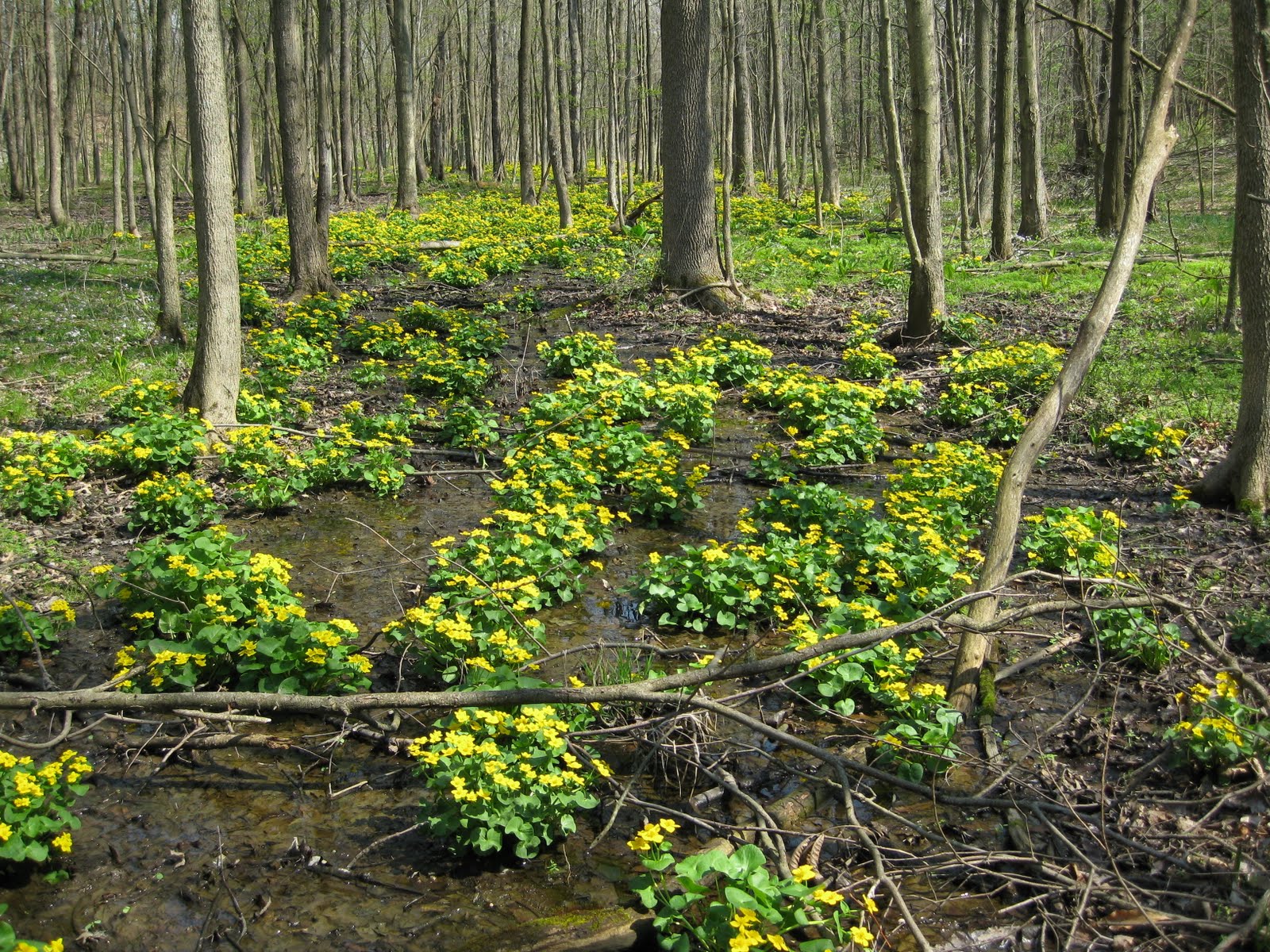
My favorite marsh is not a typical wetland. It's a riparian forest seep with open emergent marsh, and more. It's my favorite because its geomorphology is unique and because it's close to home.

Marsh marigolds in full glory.

A spring marsh is a beautiful place.

Cowslip is an alternative name given to marsh marigolds among farmers raising stock. Seeps often were 'improved' to collect water for thirsty cows and horses. These showy wildflowers grow best in mucky slippery seeps.

The best known Midwestern wildflower, common blue violets.

Common blue violet up close.

A carpet of spring beauty flowers the flank of the marsh.

Skunk cabbage plants unfurling giant leaves form a belt along the base of seeping glacial deposits. Marsh marigolds, emergent sparganium marsh, and swamp rose tier the background.

Sessile trillium, I prefer the name toadshade

Ramps, a native wild onion and popular spring fare among rural Appalachians and others endowed with adventurous palates and tolerant spouses.

Boxelder in bloom--trees do it, too.


Saturday, April 10, 2010

Earth science from NASA 's Global Climate Change site

NASA's award-winning Global Climate Change: NASA's Eyes on the Earth website offers nifty gadgets for visualizing global climate change. Check out the feature Vital Signs of the Planet for the latest on CO2 (now 389 ppm, highest in over 650,000 years), temperature records (2000-2009 was hottest decade on record), Arctic sea ice minimums (plunging 11% per decade with 2009 resulting in the third least ice cover on record), rising sea level (up 57mm since 1993), and the size of the ozone hole (about 9.3 million sq. miles).
You can see the orbits of NASA satellites, enter the Climate Time Machine, and surf rising sea levels.

This is a visually spectacular website loaded with authentic original content created by NASA scientists and interpreted by NASA's communications team. Good stuff from money well spent supporting NASA.

Wednesday, April 7, 2010

Haiku for a nice evening

clangor of thunder
cool breeze before April rain,
fast winged birds singing