Wednesday, December 31, 2008

A New Year is here...

Make a resolution...

To see a world in a Grain of Sand,
And a Heaven in a Wild Flower,
Hold Infinity in the palm of your hand,
And eternity in an hour.


William Blake

It's never too late!

Sunday, December 21, 2008

"A Christmas Bird-Census" and "that ornithological millennium"

Ornithologist Frank M. Chapman, Editor of Bird-Lore, the "official organ of the Audubon Societies," revived and revamped a quintessential American frontier tradition, the 'side-hunt', and launched a new millennium for bird conservation, "that ornithological millennium when the value of birds to man will be common knowledge."

Bird-Lore, the "official Audubon Societies publication" at the turn of the 19th Century

Frank M. Chapman launched a new era of public involvement with wildlife a century and eight years ago. The December 1900 issue of Bird-Lore (Volume 2, Number 6) carried Chapman's proposal to a growing readership of popular conservationists, particularly women:

"Now Bird-Lore proposes a new kind of Christmas side hunt, in the form of a Christmas bird-census, and we hope that all our readers who have the opportunity will aid us in making it a success by spending a portion of Christmas Day with the birds and sending a report of their 'hunt' to Bird-Lore before they retire that night."

Chapman's genius was to reawaken a popular frontier social event, long past, by way of substitution, a gathering for a bird count in place of a bird and wildlife shoot.

Chapman explained,
"It was not many years ago that Sportsmen were accustomed to meet on Christmas Day, 'choose sides,' and then, as representatives of the two bands resulting, hie them into the fields and woods on the cheerful mission of killing practically everything in fur or feathers that crossed their path--if they could.
These exceptional opportunities for winning the laurels of the chase were termed 'side-hunts,' and reports of the hundreds of non-game birds which were sometimes slaughtered during a single hunt were often published in our leading sportsman's journals, with perhaps a word of editorial commendation for the winning side."

Chapman continued,
"We are not certain that the side hunt is wholly a thing of the past, but we feel assured that no reputable sportsman's journal of today would venture to publish an account of one, unless it were to condemn it; and this very radical change of tone is one of the significant signs of the times."


Competitive indiscriminate hunts, side-hunts, for all manner of winged and wild things already were mostly a thing of the past, in large part, a victim of the Sportsman's ethics movement that had increasingly vilified indiscriminate slaughter during the later decades of the 19th Century. Side-hunts were a frontier phenomenon; they were tamed as the frontier was tamed.

Sportsmen were prominent among leaders of the early conservation movement. Up until the late 1800's nearly all conservationists were Sportsmen, and visa verse. There were social divisions over hunting wildlife during those times, but these divisions were not so much between hunters and non-hunters as between recreational sportsmen and the massive commercial kills of market gunners and pot-hunters feeding the public hunger for food and fashion among America's exploding population.

Legions of ladies launched a new century of bird conservation...

Chapman made poster-children of colorful birds, and engaged a growing army of concerned women to battle the millinery trade which fueled massive worldwide bird kills for colorful and elegant quills to adorn stylish ladies' hats. Extravagant urban bonnets might feature whole birds and even their nests with eggs arranged atop a fashionable lady's head!

Popular reaction to costly slaughter of birds for bird-adorned hats may have resulted in much more than the elimination of bird quills from bonnets; public reaction to the slaughter of beautiful birds moved a generation toward conservation and environmental concerns beyond birds and wildlife.

The Condor 3 (March 1901), 55.

A cartoon published in The Condor, a leading ornithologist's journal, pictured Chapman leading an army of women!

Chapman was buoyed by successes during that "red-letter year," 1900, which brought several giant leaps in bird conservation, capped-off by passage of the Lacy Act, the first federal law criminalizing the interstate transport of illegally acquired wildlife for sale.

Chapman's genius engaged conservation-minded people in conservation-related actions from active protest to bird-counting. This was a great leap forward from parlor-gossip and editorializing.

The first Christmas Bird Count was held Christmas Day 1900 by 27 participants in 25 locations throughout North America. The count did not immediately attract legions of bird watchers, but grew steadily, and over time became more structured and pervasive.

Today, the Audubon Christmas Bird Count (the CBC) is the largest and longest-running wildlife census, ever. This year's count period between December 14 and January 5 will involve close to 60,000 birders in thousands of counts worldwide (mostly in North America) in the 109th consecutive CBC. The CBC is an important social event for birders and naturalists, annually, much as were the seasonal side-hunts of frontier America.

Hats-off to Frank Chapman and the men and women who launched the Audubon Christmas Bird Count, and to all who helped to curtail the mass slaughter of North America's wildlife so that we may know it today!

Friday, December 19, 2008

2008: What a cool year...

It's official, 2008 was the coolest year this century! Several major worldwide climate monitoring networks have recorded the subtle cooling. The cooling is not being felt everywhere, but here in the Midwest United States it's definitely noticeable, and it's a relief.

But, wait: 2008 was very warm compared with the 20th Century. It was the 9th warmest year since 1880 according to Nasa's Goddard Institute for Space Studies (Giss). I guess we are just getting used to the balmy greenhouse climate of the 21st Century.

Global warming has not reversed, but we are getting a breather from the really warm preceding decade as La Nina, a minor climate cycle driven by Pacific Ocean temperature and current flow variations, wanes. Her partner, El Nino, is full of hot air and may be just around the corner: Fingers crossed. Let's hope the cool trend lasts a while longer.

"Peter Scott, head of climate monitoring and attribution at the UK Met Office of which the Hadley Centre is a part, suggested that in previous decades 2008 would have stood out as unusually warm."

Quoted by the BBC, speaking of 1998, the warmest year on record, Scott suggests, ""Human influence, particularly emission of greenhouse gases, has greatly increased the chance of having such warm years," he said.""

Rising greenhouse gases and exceptionally strong El Nino conditions pushed thermometers to an average of about 14.52C for 1998.

The ten warmest years since 1880:
1998 - 14.52C
2005 - 14.48C
2003 - 14.46C
2002 - 14.46C
2004 - 14.43C
2006 - 14.42C
2007 - 14.40C
2001 - 14.40C
1997 - 14.36C
2008 - 14.31C
Data: Met Office Hadley Centre

A BTU conserved is more than a BTU earned!

Read more from the BBC here.

Thursday, December 11, 2008

Great white squirrel...

Well, not really white...

A golden-white fox squirrel visiting our Delaware County, Ohio yard.

This beautiful fox squirrel (Sciurus niger) was a one-day wonder, it did not return. One fuzzy photo was all I could manage.

The leucistic* fox squirrel visited our yard recently, envious of the feeding station access our local gang of four fox squirrels enjoy. Its repeated attempts to approach our feeding station failed. The locals were decidedly unfriendly! This squirrel appears to lack some dark pigments but retains others.

* I use the term leucistic as a catch-all for all light-side pigment irregularities, reserving the term "albinistic" for completely white, red-eye wonders with two recessive genes causing total lack of pigmentation. I'll welcome a recently published reference offering a set of definitions clarifying descriptive and genetic terminology about these integument irregularities.


Monday, December 8, 2008

FLOW through a winter watershed hike...

FLOW members (Friends of the Lower Olentangy Watershed) hike Deer Run through Camp Lazarus.

Wintertime opens our temperate landscapes for easier viewing while deciduous leaves are down. Landscapes and landforms are much easier to see when they are not veiled under summertime green. This is the best time to explore geology. Members of FLOW joined Jackie and I in exploring the fresh white winter landscape and geology of Camp Lazarus Saturday, December 6.

Friends of the Lower Olentangy Watershed exploring Camp Lazarus. Left to right; Joe Brehm, Joanne Leussing, Megan Zale, Mike Welsh, Greg Hostetler, Joanne Wissler, Rich Wissler, your blogger. Photo by Jackie

FLOW is a 501C3 non-profit organization dedicated to preserving Lower Olentangy River watershed quality while hyper-development spreads through the watershed's landscape. They partner with stakeholders and work with decision-makers to guide responsible development of the watershed to protect watershed resources for all of us.

Jackie is Education Coordinator with Preservation Parks of Delaware County, and an occasional host of FLOW hikes. I joined the hike to offer geoecological insights and just to explore and have fun with fellow naturalists.

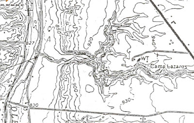
We hiked Deer Run, a small tributary of the Olentangy River south of Delaware, Ohio from near its origin along State Route 23 near the entrance to BSA's venerable Camp Lazarus, to its junction with Lazarus Run near the Olentangy River terrace.*

Topographic map of Lazarus Run and Deer Run, Delaware County, Ohio. Lazarus Run courses east-west. Deer Run joins from the north. The Olentangy River at far left.

Snow fell throughout our two-hour scramble along the steep waterway. Birds were mostly quiet, the usual cast of characters made brief appearances, Downy Woodpecker, Red-bellied Woodpecker, Dark-eyed Junco, Eastern Tufted Titmice, Carolina Chickadee, and so on. Squirrels and cub scouts were abundant.

Our walk assembled on glacial till, a flatish ground moraine left by the last ice sheet at least fifteen thousand years ago. The ground moraine supports remnant vernal pools, dry this time of year. Scattered pin oaks flag the dry vernal pools area. Shagbark hickories and a few shellbark hickories mark the slightly drier areas.

A constant crunch of hickory nuts underfoot announced a really abundant mast crop this year. Sugar maple and American beech thrive among red oaks and scattered white oaks as we approached the steepening slopes. Soon we stepped off of the thin ground moraine and onto slopes formed of shale bedrock. Oaks dominated the steep dry shale slopes.

It's a fairly short walk behind the camp nature center to where the slope begins to increase as the terrain descends westward toward the Olentangy River 120 feet below. Deer Run begins as a small drain easily straddled by a hiker near the roadway. It's dammed along a short segment for a small pond used by scouts for nature programming, then it runs free to the Olentangy River.

Deer Run deepens and steepens dramatically over a short distance. Its steep youthful profile exhibits the rapid down-cutting and headward erosion caused by the rapid cutting of the Olentangy River Valley.

Geologically speaking, Deer Run formed fast and furious and continues to form, today, more slowly. Its meandering path suggests it first found its course on a fairly uniform and low slope moraine surface before down-cutting quickly deepened the channel, greatly slowing meander-widening.

Glacial meltwater cut the Olentangy River Valley quickly through about ninety feet of shale bedrock, the Ohio Shale and the Olentangy Shale, then through about thirty feet of Delaware Limestone, a silty dark limestone with fossil beds. The resistant Columbus Limestone beneath it greatly slowed down-cutting as it is a very resistant bedrock.

The geo-speak for the pattern of watercourses in this area is "consequent drainage." It happened this way: The Olentangy River Valley formed as the Wisconsin ice sheet (or earlier ice sheet**) melted, its channel carried immense volumes of water and glacial outwash sediments southward to the Scioto River. While draining the huge volume of meltwater the river eroded deeply quickly, forming steep slopes flanking its course. Drainage along these steep slopes quickly consolidated into the tributaries we recognize today which cut down quickly to keep pace with the deepening Olentangy.

Along the way we noted the jointed (regularly fractured) Ohio Shale and we snapped pieces of fresh black shale from the streambed to smell the organic echo of long ago life (The Ohio Shale here was deposited about 365 million years ago). The Ohio Shale is 30 percent organic by volume.

The streambed was littered with glacial erratics, rocks not of the immediate area, which were originally left in moraine high above, and since have eroded free and rolled or slid downslope to the streambeds.

Our journey continued to the geological contact between the Ohio Shale and the gray silty Olentangy Shale, then back up slope through the camp.

The geological contact between two bedrock formations where Deer Run joins Lazarus Run. Above, the brownish weathered organic Ohio Shale formation. Below, the grayish silty Olentangy Shale formation. This is a sharp contact exhibiting abrupt change in sedimentary conditions.

Watch the Preservation Parks of Delaware County website and the Friends of the Lower Olentangy Watershed website for future opportunities to explore Delaware County nature and geology.

*Camp Lazarus is private property. Permission must be obtained in advance from The Boy Scouts of America to visit the camp.

**At least four major ice sheets advanced into Central Ohio based on sediments described. More ice sheets probably visited the area before these but their sediments do not survive to be described. The original formation of the Olentangy River Valley might have occurred much earlier. The valley might have been cut into bedrock, then filled with glacial sediments, then eroded again several times during the Pleistocene.

Wednesday, December 3, 2008

Crossbills and kames, nomads from the north...

We visit with White-winged Crossbills visiting a "marble orchard" on a glacial kame in Wyandot County, Ohio...

White-winged Crossbills feasting on hemlock seeds, Oak Hill Cemetery, Wyandot County, Ohio.

Old fashioned cemeteries are great birding spots, and there's something touching about beautiful birds visiting our beloved. Oak Hill Cemetery, located a few miles due south of Upper Sandusky, Wyandot County, Ohio is a great example, a wintergreen garden full of mature spruce, hemlock, and arbor vitae. Just find the community of Upper Sandusky, Ohio, then leave town going south on Route 67 a short distance to county highway 119. Go left on 119 to the first curve and enter at the gate.

Birding begins as you drive along the gravel entry passing a long hedge of tall arbor vitae ("tree of life") watching for Pine Siskins. Next, head for the nearest magnificent spruce and hemlock trees shading the "marble orchard" (That's areal photo interpreter jargon for old cemeteries, often placed on glacial kames. Kames really 'pop' when viewing 3D stereo images for terrain analysis. Cemeteries were often placed on hilly glacial kames as were orchards--both uses required well-drained soils).

Monday, Jackie and I, with naturalist Kim Banks stopped by Oak Hill Cemetery to glimpse the visiting White-winged Crossbills reported by Rick Counts and others on the Ohio Birds listserv this weekend. Rick was there and he commented that he'd been stopping by this cemetery for ten years looking for birds; perseverance pays! Through birder generosity and the internet, we all net benefit.

We saw a flock of crossbills as soon as we entered the cemetery, even before we could lower our windows to hear their cheery calls. We followed the flock to a large hemlock where birders already had them staked out. We got the low-down as we approached the observers, Ben Warner was there with Rick. There were about 40 birds total, earlier, including a Red Crossbill in the morning, and a few Pine Siskins, too.

We saw at least two flocks of White-winged Crossbills during our visit. The larger flock of 26 birds included both sexes and cooperated nicely. Red-bellied Woodpeckers were vocal, too. The red-bellied's are local but the crossbills are rare visiting nomads moving south to the tune of melodies we can't hear, but we think they are conducted by the northern cone crop cycles and such. This year is shaping up as a good invasion year--watch the listserv for a sighting near you!

Our most rewarding sighting unfolds like this: First, we hear cheery calls as a noisy flock wheels overhead passing this evergreen and that until they choose a cone-laden tree to visit. They drop in, spreading throughout the treetop and vanishing instantly among the green boughs. Next, we approach the tree and scan. Soon we begin seeing one crossbill after another high in the tree. Their antics tickle smiles across our faces. There are lots of raspberry males and limey females busily wedging cone scales. They bring to mind little parrots, the way they cling in all manner of positions, bouncing and swaying in the wind, while getting at the cones.

As time passes we see more and more as they descend the outer boughs of the evergreen, lower and lower, until nearly in reach; these guys are tame. Rick comments, "I bet these guys have never seen a human." They are seeing plenty at Oak Hill Cemetery, the word is out.

Ohio's landscape offers interested observers limitless lessons in glacial geology. It's Glacial Geology 101 everywhere you look. Geology is womb to biological diversity, even when humans intervene with evergreens. This cemetery was placed long ago by people who had to dig graves the old fashioned way, by hand. Like many older cemeteries in central Ohio, it's on a steep-sided glacial deposit, a pile of sand and gravel called a kame. Kames are ice-contact stratified drift, that's geo-parlance for water sorted coarse sediments deposited in irregular piles or terraces at the snouts of melting ice sheets.

Cemeteries often sprout on glacial kames, and grow glossy headstones and tall evergreens thanks to our cultural practices! The crossbills are attracted by the evergreens we plant, our symbols of everlasting life growing alongside our loved lost, and the birds are fed as we are comforted!

Glacial kames often grow prairie plants, too, a flora preserved in remnants today only because these cemeteries have unkempt brushy margins. These are search-central for rare plant hounds looking for new records of remnant prairie flora. Here's a tip, look closely at those hard to mow steep slopes, especially along the margins of those out-of-the-way plastic flower dumps found nearby every cemetery! I'll bet locals named this pretty spot "Oak Hill Cemetery" because it was formerly a bur oak savannah.

Glacial kames are nomads moving to a different drummer. Their scale of motion is measured in ten-thousand year intervals, a glacial pace. They are nomads nevertheless. Their rocky mix is carried from the north and left piled until the next ice sheet advance punches its travel ticket for a more southerly location. Ice sheets will came again. Our sins will be erased, and North America will begin again (less a lot of today's species), so sayeth those pesky geologists.

Tuesday, November 4, 2008

Sandhill Cranes migrate over Ohio Young Birder Club visiting Blues Creek...

Young birders explored Blues Creek Preserve, Preservation Parks of Delaware County, Ohio Saturday, November 1.

Over one-hundred American Goldfinches and dozens of Eastern Bluebirds foraged weedy parking area fields heavy with ripe seed and ornamental fruits. Bluebirds under blue skies in crisp air flavored the clear autumn morning--birding was beautiful beginning in the parking area.

Sapsucker sap wells drilled into the base of a maple tree last year no doubt provided sweet water for migrating Yellow-bellied Sapsuckers. Sapsuckers often linger to tend their wells and glean insects. Young birders learned to watch tree trunks and listen for the "Morse code" tapping of sapsuckers drilling wells.

Quiet steps and low voices stalked the nearly dry gravelly creekbed of Blues Creek dissecting the Central Ohio Clayey Till Plain in western Delaware County alongside venerable Ohio birder, Charlie Bombaci, and Park District Education Coordinator, Jackie Bain, with your blogger in tow.

The riparian belt along Blues Creek was laden with wild fruits attracting frugivores. Creekside common hackberry treetops peppered with round fruits drew hundreds of American Robins and small flocks of Cedar Waxwings.

Chicken of the woods, a.k.a. rooster comb (Laetiporus sulphureus), a common fungus found on a dead stump along Blues Creek. Identifying the fungus among us is not one of my strengths but I'm pretty sure this is a small dry growth of rooster comb. This fungus grows large bright sulphur-yellow clusters of wavy fleshy shelves. Some say the fleshy parts are good to eat.

Eagle-eye Charlie spotted cranes high overhead and counted 35 birds so high up we could not hear the croaking calls characteristic of Sandhill Crane flight chatter. Others busy inspecting an interesting tree could not pick out the high specks in the endless blue sky.

Several deeply scoured meanders along Blues Creek were found holding deep pools of water though the last rain and runoff were long ago. Young birders concluded that small fish in these pools survive long bitter winters by staying deep in water warmed by the slowly flowing groundwater. The water seeps into pools from upstream channel reservoir then seeps through and into the gravelly streambed downstream again.

Modern water tables are lower than when local fields were first cleared. Some streams dry up entirely, ground water is too deep nowadays to keep them wet: ground water is below the deepest meander scours. Many of today's dry stream miles used to support diverse small fish species and mussels year-round which have since gone the way of our once upon a time giant trees.

Lots of birds were found feeding along Blues Creek; Eastern Tufted Titmouse, Carolina Chickadee, Carolina Wren, Ruby-crowned Kinglet (one), Golden-crowned Kinglet, Red-bellied Woodpecker, Downy Woodpecker, Northern Flicker, Song Sparrow, Dark-eyed Junco, White-throated Sparrow, Blue Jay, American Crow, Red-tailed Hawk, Hairy Woodpecker, Song Sparrow and so on.

A gnarled survivor (the tree) along a dry flood swale beside Blues Creek. Long ago windfall partly pinned the much smaller younger tree. It survived by sending two rapid growing leaders toward sunshine to fuel recovery and return to vigor. Trees retain their mangled shapes from long-ago injuries. Your gnarled blogger below for scale.

Tuesday, October 21, 2008

Young birders discover new birds and bent trees...

Eager young birders found life-list birds and oddly bent trees while exploring the growing trail system at newly opened Deer Haven Preserve, a new natural area restoration taking shape in old farm fields and wooded ravines near the Olentangy River, Preservation Parks of Delaware County, Ohio.

The Ohio Young Birders Club, Delaware affiliate, gathered with parents still young at heart and Education Coordinator for Preservation Parks of Delaware County, Jackie Bain with her geoecologically-bent husband (your blogger) to explore and learn new skills Saturday, October 18.

A name-sake tree along Bent Tree Trail.

Big birds like Great Blue Herons make big impressions for new young birders, but a star emerged from among mixed-species foraging flocks: Ruby-crowned Kinglets, little bundles of supercharged feathers wing-flicking and chasing through the shrubbery close-in along the new wetlands pathway. Jaws dropped behind awkwardly held binoculars trying to follow the busy kinglets.

A flurry of foraging Yellow-rumped Warblers made a great show, too. Curious minds are eager for new tidbits and tales so our small group learned to look past the birds to see much more and to question what they saw. "Why do they have yellow rumps?" "Why do different kinds of birds fly around together?" "How can you tell those black birds flying up there are Red-winged Blackbirds and Brown-headed Cowbirds?"

Cedar Waxwings whistled overhead in small flocks while we discussed invasive bush honeysuckle. It's bright red fleshy berries carry just enough sugars to keep the birds coming. Seeds are dispersed in bird droppings along fencerows and woodlands, everywhere. It's taking over!

Blue Jays congregated in American beech tree-tops scurrying for ripe sunshine-filled beechnuts and raining them to the ground around us while we discussed family chores and family economy long ago when abundant beechnuts were important food for American Indians and early settlers.

A Belted Kingfisher rattled from the pond nearby, a good beginner's song to get young birders thinking of bird listening, not just bird watching. "How do you know that was a kingfisher?"

Young birders found curious caddisfly larvae cases made of little bits of stone glued together on the undersides of dry streambed rocks as we discussed the erratic rounded rocks we overturned--those rocks and boulders so out of place on slopes and collecting in the streambed. "Where did they come from?"

The crystalline igneous rocks rode glacier ice all the way from Canada. Young birders turned their binoculars to see backward through objectives magnifying the interlocking crystals gleaming on a freshly chipped granite boulder. "How did they get here?"

We searched tree trucks for the diminutive Brown Creeper calling nearby but could not find the little camouflage expert as we talked about the anachronistic honey locust pods, scattered trees were drooping under their burden of long leguminous pods. Many pods already had accumulated on the ground under the trees and remained uneaten, though some were nibbled by seed predators that kill seeds rather than distribute them.

Mammoths and Megalonyx (the giant Jefferson's ground sloth, extinct) are no longer around to chew the sweet pods and swallow the small slippery seeds whole then distribute them in their dung*. Curious young minds devour tales of giant beasts of yore; just don't use words like, "anachronistic" and "leguminous" during the telling!

A Hermit Thrush scolded gently from the brush in the ravine where Eastern Towhees called repeatedly for tea, "Drink your tea!" American Robins "laughed," Downy Woodpeckers pecked, and huge Turkey Vultures raised from nearby roosts to ride early thermals just over the heads of young birders discovering bent trees.

Bent Tree Trail, a tree story...

A mangled tree along Bent Tree Trail, Deer Haven Preserve, Preservation Parks of Delaware County, Ohio. This old sugar maple is a survivor. The major limbs were broken-off close to the trunk during an extreme weather event. It survived by sending fast-growing leaders from the broken limb-tips toward the sunshine (candelabra shape).

Injured trees don't heal wounds, they wall them off to protect undamaged wood and bark near the wounds. Mangled trees retain the scars of their battles with weather and wildlife even when fully recovered.

Our recent hurricane Ike brought record winds to central Ohio and left behind a new pattern of damage to trees, extreme in places, light in others. Our young birders discovered Ike-damaged American beech trees among older fully recovered beech and sugar maple trees with severe damage from long ago, still obvious.

This huge American Beech along Bent Tree Trail lost its top forty-percent or so to Hurricane Ike. Several large trees nearby are severely damaged. Their location along a ridge slope leading toward the Olentangy River valley put them in harms way as high winds tore through the valley during the hurricane remnant's assault.

Badly mangled trees take on curious shapes inspiring wonder and begging explanation. Some large unique mangled trees inspire folklore tales. Surely they must have been manipulated by people. Didn't American Indians intentionally shape trees to signal the entrance to trails, or the direction of important pathways? No, says my professional archaeologist friend.

Nature has shaped wondrous trees in central Ohio with wind and ice many times since Pleistocene glaciers retreated and forests spread northward from southern refugia to raise their grand nearly continuous leafy canopies over the Midwest.

The old sugar maple pictured below is one of the bent trees that inspire wonder and it's one of the trees for which Bent Tree Trail is named. It was a young sapling before the oldest of the tree-watchers among us were born, but not by much. It certainly was not around when American Indians might have had reason to mark trails.

A closer look explains this tree's recovery. Look at the navel-like ring scars at the bends of large limbs, the successful leaders at the tips of limb stumps, and the failed leader close to the trunk on the large limb.

A careful look at this tree, and at damaged trees nearby, suggests a long ago severe weather event is the origin of the damage. The view pictured above is brightened and tightened from the first image to more easily see the scars holding the secret to this tree's recovery.

The close-in heavy branch pictured retains an obvious ring scar at the bend, as does the more distant limb. These scars closed-off damage around the breaks where limbs severed long ago. The nozzle-like protuberance leading to the ring scar is smaller in diameter and offers us a good clue to the size of the branch at the time it was broken-off.

Most of the large limbs of this tree show evidence of breaking-off at the same time and close to the trunk due to the same extreme weather event decades ago: Likely caused by very heavy ice-loading and high wind. I'll give odds it was an ice storm.

The major limbs were broken-off so close to the trunks of several damaged trees that all the determinate-growth bud sprouts (limited growth twig buds that produce annual growth in healthy trees) fell away with the limbs lost. The fast-growing tree-tip no doubt fell away, too. The living limb stumps sprouted indeterminate-growth leaders (fast and tall growing sprouts like the tips of fast-growing saplings, triggered by reduced hormones which normally suppress fast growth below the tips of trees). The leaders bolted upward to spread leaves in the sun.

Only the successful leaders remain these decades later, with one exception. Two indeterminate-growth leaders are visible on the large branch in the image above. A successful leader near the tip of the limb gives the tree its odd shape. An unsuccessful leader closer to the trunk was shaded-out after some years and remains in evidence because the dead stump has not yet fallen off the tree limb.

Horizontal limbs tell a tale of habitats. The unique tree pictured likely sprouted from its whirly-gig seed blown by the wind into a cut-over brushy habitat or a successional pasture with widely spaced larger trees very unlike the small tall-trunked trees of the young forest growing around it today. It's near-horizontal original limbs suggest that it bolted above surrounding competition to open a wide crown at moderate height with major branches reaching broadly outward from the trunk to capture sunlight above the brush and smaller trees surrounding it. Sugar maples are prone to crown low; given a chance they do so.

The combination of horizontally spread major limbs and vertical recovery leaders give this tree its unique appearance. Its bizarre shape will continue to inspire wonder and folklore tales for thousands of visitors for many years to come, along Bent Tree Trail.

When did a storm mangle the tree...

An increment borer drilled into the trunk of a tree can sample a pencil-thin core of tree rings for counting without stressing the tree very much. A core sample from our mangled tree would show an obvious series of very closely spaced rings for several seasons after the storm that mangled the tree, until it recovered its vigor. Undamaged older trees nearby would not exhibit the same cluster of closely spaced rings during the same interval.

American Beech trees recovered from historic damage.

Two American beech trees show damage and recovery that appears to date from the same historic severe weather event which mangled the bent sugar maples. The tree in the top image lost a major fork on its right side. A leader sprouting from near the old break has grown nearly equal in size to the undamaged fork, and has nearly obscured the old scar. The tree pictured below lost its top at the same time but retained a couple major limbs and was able to fill-in the crown with a cluster of awkward new limbs.

*Under the anachronism hypothesis, anachronistic fruits are those large fruits like honey locust pods, Kentucky coffee tree pods, and Osage orange "monkey brains" or "hedge apples" that are not wholly consumed by living large herbivores native to North America which swallow chunks of fruit with intact seeds, scarify (weaken the seed coat within the gut or between teeth) and distribute the seeds ready to germinate in scattered dung heaps away from the plant that provided the fruits consumed. Today, only horses and cattle (re-introduced with humans to North America) serve to distribute honey locust effectively (deer distribute the seeds somewhat poorly). The scattered honey locust trees we found during our walk are a clue to past land use in the area we visited. Anachronistic fruits evolved with an herbivore partner or partners which effectively distributed the species seeds, but now are extinct.
See: Barlow, C. 2000, The Ghosts of Evolution. Basic Books.

Sunday, October 12, 2008

Wind power: New wings join raptors over Allegheny Escarpment...

Wind power is taking flight on colossal white wings over the Allegheny Escarpment along Shaffer Mountain's skyline in western Pennsylvania. Photo by author 10/11/08.

Migrating raptors have owned the airspace over the Allegheny Escarpment for millions of years. Now, mega wind power is colliding with ancient raptor flight paths and with human sensibilities.

A world leader in wind power development is setting up housekeeping in PA. Giant Spanish turbine manufacturer and wind farm developer, Gamesa is bringing Union-friendly green collar jobs and wind-borne megawatts to PA. Not all citizens are pleased. Local roadside signs protest the wind farm project. One example found at the ends of dooryard drives beside both McCain--Palin and Obama--Biden signs reads, "Gamesa is harvesting subsidies, not green power."

Many two-megawatt turbines are spinning on towers already. One website claims forty are slated for erection along the escarpment to complete this pioneering project. Special agreements were written to allow launching the project. Regulations will be penned as experience with mega wind power demonstrates impacts. No legislation currently exists regulating numerical impacts on wildlife (birds and bats, mainly), or requiring remedies other than changing requirements for operation. Current agreements require monitoring and reporting.

Wind turbines along the southern Allegheny Front.

An aerial photo shows the close spacing of towers currently testing the winds and flight paths of birds and bats along linear Allegheny ridge tops. I drove by several similar clusters near Route 160 between Summerset and Center City, PA in early-October.

Both presidential candidates promise large investments in alternative energy development along with a slew of green-collar jobs. No doubt, wind turbines will become a common sight on windy landscapes throughout the United States. How will wind power development impact birds and bats? That depends on placement. The photograph of turbine assembly above was taken just a few miles from The Allegheny Front Hawk Watch...

Hawk counters with the Allegheny Front Hawk Watch search the sky for raptors from their Shaffer Mountain lookout.

More than twenty pairs of binoculars rose to observers' eyes in unison when someone first called out, "Heavy bird coming in over the notch." Excited hawk watchers found the large bird and followed its approach, waiting to see more as it grew larger in view with passing seconds. Someone braved a preliminary identification, "That's got to be an eagle." A murmur of agreement arose in the crowd of onlookers. Then, without bending a wing, the big bird tipped, exposing long white patches at the base of flight feathers of wings and tail. "It's a golden," voices called in unison. Soon its smallish head (compared to a Bald Eagle juvenile) and sunlit golden hackles on its nape became obvious to all. Someone called out, "It's a juvenile Golden Eagle," The official counter added a tic-mark to the list of birds seen this day. It was the third Golden Eagle for the day at the Shaffer Mountain lookout where the Allegheny Front Hawk Watch is supported and conducted by volunteers with the Allegheny Plateau Audubon Society and guests.

The Shaffer Mountain lookout is situated on a western bulge of Shaffer Mountain overlooking a vast valley 800 feet below. It's the leading edge of the Allegheny Escarpment, the eastern continental divide.

Migrating birds of many Families, particularly raptors, move eastward from as far west as Alaska before turning southward at the Appalachian Mountains. The Allegheny Escarpment and the knife-edge ridges of the Ridge and Valley Province, particularly the Kittatinny Ridge of eastern PA. These mountains greatly predate the Pleistocene glaciations and shaped the migratory movements of birds before multiple glacial advances reshaped North America and bird migration. The sinuous mountain chain leads birds to warmer climes on wind-assisted wings.

These ancient flight paths may be at risk. We don't have enough information today to guide choices beyond obvious avoidance of traditionally observed pathways. The vigilance of birders will help guide future placement of wind farms so we can reduce bird losses while gaining green jobs, and reducing carbon tonnage in the atmosphere.

Monday, May 5, 2008

Recreation ecology...

The science and practice of Leave No Trace.

The footprints of humanity track our natural world in every corner of the globe and in many ways. We are part of the ecology of wild places. Outdoor recreation leaves tracks and traces on our green spaces and wildlands alike. Often our collective tracks and impacts coalesce into trails and social trail networks, campsites and campsite clusters, mud puddles, migrating fire rings, severely compacted and eroded soils, and establishment of invasive species brought into wildlands by our wheels, boots, and boats. Our favorite wild places are threatened by careless use.

Fragile beauty, whether a riparian ecosystem or a single flower, is too often impacted by careless recreational use, even in the most remote wild areas. Large white trillium (Trillium grandiflorum) and many other native plants will wither away where frequent campers compact the soil.

The Leave No Trace Center for Outdoor Ethics offers outdoor recreation enthusiasts guidance for reducing impacts to natural areas. Their science-based materials offer suggestions for diverse user groups from horsemen and fishermen, to hunters and backpackers. Leave No Trace (LNT) was developed by experts with federal land management agencies and by the National Outdoor Leadership School (NOLS). Agencies worked with NOLS to combine many agency and private initiatives for reducing outdoor impacts into one science-based approach.

We may view our personal impact in the great outdoors as inconsequential, but Virginia Tech researcher Jeff Marion sees our cumulative impacts through the prism of scientific investigations, and what Jeff sees threatens the quality of our recreation spaces from city parks to national parks, and our wild places from the back-forty to federal wilderness areas. "What we need is an outdoor ethics revolution" Jeff explains. Jeff traveled to BSA's Camp Oyo surrounded by Shawnee State Forest during April to offer professional instruction to LNT Master Educator trainees, your blogger included.

Recreation ecologist Dr. Jeff Marion instructing BSA scouting council leaders in the science and practice of low impact outdoor recreation during a Leave No Trace Master Educator Course, six days of theory and practice. Jeff 'wrote the book' (and many scientific papers) on reducing impacts to wild places while sustaining outdoor recreation opportunities.

One common misconception among backpacking enthusiasts is that spreading out their tent sites in popular camping areas is good for the environment. Unfortunately, sensitive locations become established campsites after as few as three uses in a season. Even more durable locations tend to become campsites after just a dozen uses.

Interestingly, campers tend to gravitate to the same locations when searching for a campsite. Quickly, after just a few uses, lightly disturbed locations become even more inviting to others seeking privacy and an easy place to set up away from the crowd. This casual site selection process results in expanding campsite clusters with many extraneous satellite camps in sensitive areas. The same thing happens with casual trail selection. A game trail becomes an eroded shortcut after surprisingly few uses.

The answer? When camping and hiking in popular remote areas or frontcountry parks and campgrounds, it's better to concentrate use on already compacted sites and on managed trails. Some sites and pathways must be sacrificed, then managed for use by frequent campers and hikers while surrounding potential sites are left to recover.

Many outdoor recreation enthusiasts recognize the wear and tear in their favorite wild places. Many do not realize their methods are damaging the resource. Recreation area managers deal with the damage daily.

Wildlife management is a huge concern in popular wild places. Unfortunately, slogans like, "Fed wildlife is dead wildlife." often fall on deaf ears because our individual impact seems so trivial at the time. Throwing those cold French fries out the car window to that bear gets us a great close in photograph. Did you ever wonder why that bear and her cubs are hanging out by the roadside?

The LNT message is summarized in Seven Principles:

Plan Ahead and Prepare
Travel and Camp on Durable Surfaces
Dispose of Waste Properly
Leave What You Find
Minimize Campfire Impacts
Respect Wildlife
Be Considerate of Other Visitors

Legendary through-hiker and Leave No Trace expert Charlie Thorpe offering guidance to trainers in training in Ohio's Shawnee Wilderness Area, Scioto County during a trail break.

Charlie Thorpe has carried the LNT message to tens of thousands, worldwide. And, he has logged many thousands of miles on the big trails like the AT (the Appalachian Trail, the whole thing), and the PCT (the Pacific Crest Trail, again, the whole thing), and so on. Charlie has lived the message from trail to trail, event to event. He is a passionate supporter of scouting, worldwide. Last year Charlie took the LNT message to world scouting's 100 year celebration in England where tens of thousands participated.

Scouting youth spend millions of camp nights in the great outdoors annually. Outdoor ethics have been integral to scouting from the beginning 100 years ago. Nonetheless, ethical practices have changed with increased use of wild places, and some scouting units have performed poorly in the past, by using old fashioned approaches like ditching tent sites or cutting firewood in inappropriate places. The shear number of youth going camping through scouting annually is a wonder and a challenge. An occasional bad example reflects on the whole organization.

Today, scouts are practicing LNT's scientific methods more and more. Scouting rank requirements are changing to require these scientific practices for all advancement levels. Each of scouting's traditional programs, Cub Scouts and Boy Scouts, and the rapidly growing coed Venturing program for older youth, offer age-appropriate lessons and skills development.

There have been low impact slogans for thirty years, now; "Pack it in. Pack it out", "Give a Hoot. Don't pollute." "Take nothing but photographs, leave nothing but footprints.", and so on. LNT brings them all together through peer-reviewed science, and passionate educators.

Leave No Trace, outdoor ethics and skills are all about the conservation of wild places and recreation spaces. Check out LNT today.

A personal thanks to Charlie Thorpe (traveling from Alabama) and Jeff Marion (traveling from Virginia) for their extraordinary generosity in sharing their skills and message. Thanks also to Al "Yeti" Martin, course lead instructor, Clark Sexton (traveling from Georgia), instructor, Irv Martin, instructor, Bob Havreberg, instructor, and instructor and course director Dr. Kerry Cheesman.

Monday, April 21, 2008

Field of dreams... for ramp hunters

A carpet of ramps greens the rounded hills of this eroded glacial terrace in Ross County, Ohio. Appalachian dreams conjure scenes like this...
Ramps (Allium tricoccum)

April is ramp season in Appalachia where communities celebrate ramps in songs, feasts, and festivals.

Pungent ramps are prized by accustomed connoisseurs, but they may be an acquired taste for the rest of us. Their sticky odor resembles onion, laden with garlic. After an Appalachian feast of fresh bulbs and leaves, their smell permeates the air in a moving cloud, following the man with a ramp-eat'n grin on his face. My friend Jimmy from Poca, West Virginia swears his wife keeps him in quarantine for days after a good feast of ramps. Some say it takes three days for the aroma to work its way through your pores.

Ramps with dogtooth violet (Erythronium americanum)

I'll bet readers can suggest recipes for newbies wanting to try a new gastronomical experience. Your blogger is not a connoisseur.

dogtooth violet (Erythronium americanum)

My recent short hike near home to confirm a Great Horned Owl (found tawny fledged young) for the Ohio Breeding Bird Atlas II, and to stretch an injured heel close to home, was rewarded by dappled colors of spring flowers under faintly blooming trees along the riparian corridor of North Fork Creek.

Common serviceberry (Amelanchier arborea)

Virginia bluebells (Mertensia virginica)

Cutleaf toothwort (Cardamine concatenata)

Monday, March 31, 2008

American Kestrels are beneficiaries of OOS partnership with AEP and The Wilds

Jim McCormac, OOS President, pointing out a commanding hilltop on The Wilds where AEP ReCreation Lands staff will mount an elevated perch for birds of prey. The flag marks a roadside location for a kestrel box pole.

OOS (Ohio Ornithological Society) Conservation Committee members met with AEP (American Electric Power) staff, and staff members from The Wilds to flag locations where AEP will erect recycled utility poles for mounting nest boxes and raptor perches at The Wilds and on AEP ReCreation Lands nearby during the coming weeks.

The three organizations anteed-up, betting the birds will benefit. OOS is covering the cost of quality kestrel boxes manufactured by OOS member, NASA engineer Craig Rieker. AEP will bring in poles and heavy equipment to set them up, and mount the boxes and perches at about 20 locations flagged for kestrel boxes and another ten locations marked for raptor perches at The Wilds and on AEP ReCreation Lands.

Checking out International Road, The Wilds, to locate kestrel boxes and raptor perches at optimal positions. Left to right: Cheryl Harner, OOS conservation committee; Tom Bain, OOS committee chair; Al Parker, Education professional and naturalist at The Wilds; and Jim McCormac, OOS President and conservation committee member. Jim put the pieces in place for this partnership success. Al Parker will help install poles and work the constructions into the fascinating mission of The Wilds.

Birders will benefit, too. Raptor perches located on commanding hilltops will offer large raptors like wintering Golden Eagles a place to perch, in view of birders with scopes. Another project in the works; a birding trail offering birders guidance and enhanced access to The Wilds and to AEP ReCreation Lands' birding hotspots.

Checking out old nest boxes for second life opportunities at AEP's Windy Hill ReCreation Lands facility. Jim McCormac, right; your blogger, middle; and Dave Dingey, of AEP, left. Dave Dingey is making it happen by bringing AEP's resources and manpower to the mission.

American Kestrels are a common bird in decline. This partnership will work to help them remain common by adding nest cavities in the grassland habitat presented by reclaimed surface mining lands. Nest cavities are vital for maintaining the population of American Kestrels. OOS is developing education and research partnerships to study the next box success and bring lessons to light for keeping kestrels common.

Big businesses, from major power corporations like American Electric Power, to agricultural businesses, from family farms to global agribusinesses, are key to future successes in keeping common birds common in our changing environment. As human population grows, increasing demand for food and power worldwide, partnerships must help protect biological diversity. My thanks to AEP for their support of this project, and their many other committed actions toward reclamation, habitat improvement, and outdoor recreation development on the topsy-turvy hills of southeastern Ohio.

A Pleistocene Serengeti: A scene that might have been plucked from the Pleistocene wilds of Ohio just decades after deglaciation, found at The Wilds.

Waterfowl migration is a spectacle at The Wilds and throughout AEP's ReCreation Lands on scores of reclamation ponds. Distant Tundra Swans, Lesser Scaup, Ring-necked Ducks, American Black Ducks, Red-breasted Mergansers, Hooded Mergansers, Bufflehead, Common Loons, Green-winged Teal, Mallards, Canada Geese, and other species use the many ponds of The Wilds and of AEP's ReCreation Lands nearby during migration.

Cheryl Harner and Jim McCormac looking a bit Lilliputian in the gaping maw of progress, Big Muskie's bucket. This giant scoop turned Ohio's hills topsy-turvy to liberate fossil sunshine: Coal-fired energy powers most North American production. Big Muskie's bucket is exhibited at Miner's Memorial Park near McConnelsville, Ohio.

Big Muskie, a giant drag-line excavator, dwarfs its bucket. The bucket is seen at the end of the cables below ground level in this illustration displayed at Miner's Memorial Park. A series of mounted illustrations walk visitors through the 20th Century history of surface mining in southeastern Ohio.

Thursday, March 20, 2008

Yocatangee: A view of nature and geology in southern Ohio

Intrepid naturalists joined me in a mix of rain and snow for a geology walk at the Ross County Park District's Earl H. Barnhart Buzzards' Roost Nature Preserve, overlooking Yocatangee Gorge(1) March 22, 2008. Annually, we ponder the complex geology of this glacial boundary region while searching for harbingers of spring.

Naturalists puzzling over the geology of Yocatangee Gorge; the remarkable gorge of Paint Creek west of Chillicothe, Ross County, Ohio. Historian Kevin Coleman, left, with Gary McFadden, resident naturalist, viewing distant Paint Creek from a Berea Sandstone ledge along the south rim of the gorge*.

Dark crumbly Sunbury Shale is found exposed atop thick tabular Berea Sandstone along the gorge rim. Berea Sandstone forms the superstructure holding the rim in place. Hardy Virginia pine (Pinus virginiana) colors the gorge rim with green highlights, year-round.

Chestnut oak (Quercus prinus) is common on dry hilltops, and it's a dominate near the rim of the gorge on gentle slopes of Sunbury Shale. The rim is a harsh dry habitat during the heat of summer. Chestnut oak thrives on dry acid slopes, too harsh for many tree species.

Detail of deeply furrowed chestnut oak bark.

A wintergreen native orchid, Adam and Eve, a.k.a. puttyroot (Aplectrum hyemale), gathers sunshine when trees and most leaf-eating insects are dormant. Puttyroot is common in the wooded uplands of Buzzards' Roost Nature Preserve. Its green winter leaves are distinctive. Their prostrate habit and dry papery texture, resembling recently wilted dead leaves, may be adaptations to discourage grazing. The leaves will disappear as other plants leaf out. A solitary stalk will rise and flower later in spring.

Crippled cranefly (Tipularia discolor) is another fairly common wintergreen native orchid found in wooded uplands at Buzzards' Roost. The green leaves are thicker than puttyroot leaves, broad chordate (heart-shaped base), warty, and deep-purple underneath. The purple color comes from anthocyanins, pigment compounds that protect leaf cells like a sunscreen and may absorb heat, speeding chemical processes making sugars. The color may also signal unpalatability to grazers. Like puttyroot, cranefly orchid leaves disappear as other plants leaf out. Later in spring a solitary flowering stalk will bloom with cranefly-resembling flowers.

Cutleaf grapefern (Botrychium dissectum) is a winterbronze fern common on wooded and old field uplands of Buzzards' Roost, but often overlooked. Its succulent leaves blend with leaf litter. Cutleaf grapefern is lime green as it sprouts in fall, bronzing with freezing weather, overwintering, greening again in warm spring, and sending up a fruiting stalk late in spring before disappearing in summer heat.

Blocky "alligator skin" bark of common persimmon (Diospyros virginiana). This tree grew from underneath an old wooden sty where a mammal may have carried fruits from another tree nearby, leaving the seeds behind to grow up through the old wooden structure. The sty has been demolished, leaving the interesting tree.

Vernal pools and small ponds on "The Roost" are busy with breeding amphibians. Jefferson's salamander eggs, spotted salamander eggs, and wood frog eggs are abundant. Underwater egg masses are visible inside the observer's shadow.

Puzzling over geology...

A jig-saw puzzle missing many of its pieces and without a reference picture on a box-top would be declared a lost cause, the pieces thrown away by all but the most determined puzzleers. Now mix these random pieces with those of several other puzzles strewn in the bottom of a child's toy box and you have a useless collection of squiggly pieces-parts, by any reasonable standard. Even so, extreme puzzleers can't resist the challenge.

Yet, sorting these commingled puzzles into comprehensible images is child's-play compared with piecing together a view of the complex geological history of a place like Yocatangee Gorge, the gorge of Paint Creek just west of Chillicothe, Ohio.

Geology is a puzzle on a grand scale; a four-dimensional solution (three dimensions plus time) found without the benefit of a reference picture. It's a series of puzzles, really; a puzzle assembled from other puzzles. The solution is a time-lapse video, not a static image. Even simple landscapes tell convoluted stories. Every piece of each geology puzzle is as much a process as a material, and more inference than absolute. Most pieces of the original puzzles are missing, eroded away, lost in time like grains of sand in a mighty Ohio River flood. You can never really know if you have re-assembled geology puzzles correctly: and someone else will surely declare your solutions imperfect, no matter how comprehensive your effort. Nevertheless, the journey is a joy for the geologist-puzzleer.

A grand puzzle of stream piracy...

Yocatangee Gorge is a grand puzzle resulting from stream piracy(2), but how?. The existence of this new narrow gorge of Paint Creek, cut through a particularly hilly section of the Allegheny Plateau, makes no sense in terms of casual landscape logic(3), until we consider the impact of major glaciations. This beautiful gorge, and others found along Ohio's glacial boundary, are the result of at least two Icehouse climates(4), major glacial episodes in Earth's history.

Yes: The two most recent glaciations, the Wisconsin and the Illinoisan glaciations, were important formative events making the new gorges near the glacial boundary in southern and central Ohio. But, I'm not referring just to these fairly recent events of the Pleistocene. I'm suggesting a very ancient origin for parts of the Yocatangee Gorge puzzle(5), at least 350 million years old, a direct result of a Paleozoic glacial age during the Lower Mississippian Epoch of the Carboniferous; a Pleistocene-like time when continental glaciers smothered large areas of Earth long before the Pleistocene, near the beginning of the coal age. An up to date chart.pdf detailing the Geological Time Scale is found at Stratigraphy.org.

The shape of the gorge...

Look at the topographic map of the gorge seen here at 1:200,000 scale. The small red cross-hairs are centered on the map at the entry to the gorge. Chillicothe is seen at right. Route 50 is a bold red line trending SW to NE through the old broad valley of Paint Creek at left, the flattish white area. If you are new to topographic maps, just remember to see steep slopes wherever the brown squiggly lines are close together; where they are far apart, see flattish ground. The steep slopes and hills often are forested, indicated by green shading.

Now, zoom in to 1:50,000 scale to see more detail where the stream leaves its broad valley and enters the hills. You will notice right away that Paint Creek occupies a really broad mature valley along Route 50 as it flows northeastward. Abruptly, the creek turns, flowing southeastward among steep hills, through a young "V" shape gorge. WHY?

Some bedrock background...

Ohio exhibits pancake sedimentary bedrock geology. There is a 'basement' of mostly very old igneous and metamorphic rocks buried deep below a 'superstructure' of Paleozoic sedimentary rocks; multiple layers of flattish to somewhat tilted limestones, sandstones, and shales. And, a 'roof' of glacial deposits covering most bedrock in the northwestern two-thirds of the state. The layers of Paleozoic sedimentary bedrock are stacked like pancakes leaning on a breakfast plate margin. The pancake layers are exposed edgewise north to south through central and eastern Ohio as seen in the Bedrock Geological Map of Ohio. The layers dip toward the east just a few degrees in central Ohio. Yocatangee Gorge offers a view of Ohio's Devonian and Mississippian pancake geology and of deep time spanning 365 million years.

To be continued...

Notes:
*The gorge rim is a limited-access area reserved for science and interpretive programs offered by scheduled naturalists. Visitors, please don't approach the sensitive gorge rim. Stay on leaf litter well away from the edge. Foot traffic is erosive and destructive of rim-slope plants. Many rim rocks are thin sandstone block overhangs vulnerable to failure.

(1) "Yocatangee" is a name I have proposed for this deep gorge of Paint Creek found a few miles west of Chillicothe in Ross County, Ohio. The connection of the gorge with the Native American "Yocatangee" will be the subject of a future blog entry. The name derives from maps summarizing features noted in early surveys; contact-period names and descriptions applied to features in southern Ohio. These are from two sources: The first, a map of "Indian Villages..." and other features by Lewis, G. L. and Dawley, W., 1901, and the second from notations on Peter Kalm's Travels map of 1771. Today, the gorge is commonly called "Alum Cliffs" or "Alum Cliffs Gorge" or "Paint Creek Gorge." The former name is found on topographic maps, the latter name often results in confusion with the beautiful western Ross County gorge of Paint Creek cut into limestone and dolomite, now mostly flooded by Paint Creek Lake Dam.

(2) Stream piracy results when a stream intersects a second stream, diverting the second stream's drainage through the first streams channel, pirating the second streams water. Stream piracy occurs frequently as landscapes mature. Most stream piracy results from headward erosion. The headwaters of streams continually progress headward (the direction opposite the current flow-direction) by an erosive process bringing more and more elevated terrain into slope toward the stream through down-cutting, a high energy process where stream gradients are steep. The piracy of ancient Paint Creek resulted through a different process involving glacial lake formation and spillway down-cutting where the deepening lake breached a col between hills: Spill-over piracy. The earliest description (of which I'm aware) of spill-over piracy proposed for this gorge is described and illustrated by Jesse E. Hyde in Camp Sherman Quadrangle, 1921, Geological Survey of Ohio Fourth Series Bulletin 23.

(3) Landscape logic is applied common sense. Landforms evolve slowly through steady predictable processes, and occasionally by sudden changes like volcanoes, landslides and glaciations. Formative factors like rock type, climate, and elevation operate in predictable ways. Geologists often speculate on the evolution of landscapes by applying landscape logic.

(4) Icehouse climates are major cold periods of Earth climate during which series' of continental glaciations dominated temperate and polar regions for spans of millions of years. There were at least four Icehouse climate regime's prior to the the most recent, the Pleistocene.

(5) The Yocatangee Gorge puzzle solution attributing Bedford Shale and Berea Sandstone silici-clastic deposition to Devonian-Mississippian glacio-eustatic response, I present herein, has not been published in peer-reviewed literature and remains speculative (as far as I know-I'm not very active in research geology): Certainly, there are timing issues to work out more carefully. This solution was inspired by carbon isotope work suggesting a Kinderhookian-Osagean chill, like the work of Saltzman at The Ohio State University, a growing consensus around glacio-eustatic causation for Carboniferous and Permian cyclic sediments-the coal measures, and particularly by a published re-interpretation of the Blackhand Sandstone (Hocking Hills) as an incised-fill resulting from glacio-eustatic sea level changes with Lower Mississippian glaciations, a West Virginia University PhD dissertation by David L. Matchen, 2004.